M3D
 Command
line: M3D
Description:
create 3D
model
 TopoLT
toolbar:

Menu:
TopoLT » 3D Model » Create 3D model
Using this command you can create 3D model of field using
points that have X,Y,Z coordinates or lines or polylines. Interpolation method
for this version of program is only triangulation method with linear
interpolation (Triangulation with Linear Interpolation).
Options available for this command are:
·
3D model can be realized in gradual colors that vary from minimum
to maximum of elevations (performance on colors is limited at 256 colors
because of CAD). Choosing minimum and maximum color can be done using program
configuration option or through command Om3d;
·
from points that were selected to realize 3D model can be
eliminated those with a certain elevation, default value being for point with
elevation 0.000;
·
when creating 3D model you can select lines and polylines in which
3D model has a forced change of slope. Selected lines and polylines must pass
through topographical points with X,Y,Z coordinates or must be draw in space;
·
3D model can be limited in a perimeter through selecting a
polyline that marks zone in which you want to create 3D model. The 3D model
that was built using all selected points will be cut through this limit.
Recommendation: if you don’t have points with elevation but there are
entities drawn in space (3dpoly, 3dface, polygonmesh, polyfacemesh, line, etc.)
then you can obtain points with elevation from these entities using command AutoPct.
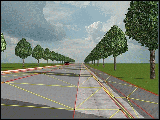
Cases in which is applied a forced change of slope when
creating 3D model:
Legend:
|
|
points with X,Y,Z coordinates
through which 3D model is created |
|
|
lines of forced change of slope |
|
|
triangles that are formed when
creating 3D model |


Fig. 1
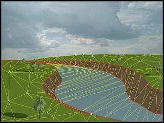
Fig. 2