Georeferencing images using TopoLT
In this exercise you will make correlations of inserted raster images in order to place them in a coordinates system.
These transformations are made by selecting one or more corresponding points between the image and the coordinate system.
The program uses several types of transformations. During the transformation you can make other changes to the images, such as: saving in other formats, trimming or changing color format.
For more information about this functionality please see the Help file.
1. To complete this exercise open 4_1_RasterEx.dwg from Example folder in TopoLT installation path (by default it is C:\Program Files\TopoLT\Examples).
2. In TopoLT go to Images » Image Options.
Together with the transformation you can make the following changes to images:
– Images can be saved in the following formats: .bmp, .jpg, .pcx, .png, .tga, .tif.
– Change the color format: from Black&White up to True color (32bit)
– Trim the image to keep only the area you are interested in. Trimming can be made on the contour determined by the minimum and maximum of the constraint points or outside this limit with an offset (in case you want to keep information about grids, map name).
– Images can be clipped on the constraint points. Clipping is useful to view only the area of an image where the map is drawn, the rest of the image is hidden. Check the option Clip Image – Boundary.
– After transformation the images can be made non-selectable by turning off the image frames (ImageFrame = Off).
– Choosing the Transformation Options. In this example we will use the Affine and move points (min. 4 points), which is useful for scanned images because the deformations are not constant and we cannot apply only the affine transformation.

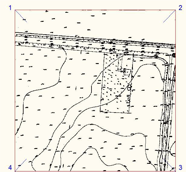
In drawing 4_1_RasterEx.dwg, you will correlate source points with destination points using the endpoints of the blue lines. For a correct correlation select carefully the source and destination points.
For the upper image the transformation points are 1,2,3 and 4.
Go to Images » Transform Images or type timg in the command line.
Select image: select the upper image
Base point /Undo: select the upper-left image corner to move in point 1
Destination point/Undo: click point 1

Repeat these steps for points 2, 3 and 4. When finished press Enter.
Insert a new image (Yes/No): choose No
The following window is displayed:

On the left side are displayed all images inserted in the drawing and in the center are coordinates for reference and destination points. In case you select more points than the minimum necessary you can eliminate the wrong points from the table.
The button Save Points generates a file with coordinates for reference and destination points. Using Load Points button you can load point coordinates from an external file.
Press Transform button. The image is moved to the new coordinates.
4. Repeat the same steps for the lower image. This time the transformation points are 1’, 2’, 3’ and 4’.
5. After transformation, if you want to see the whole image use Image Clip command or type imageclip (has to be OFF).
6. At the address where the image is saved the program saves new files with .bk1, .bk2 extensions. These files are the initial images saved before modifications. They can be used to revert to the original images using the Images » Undo images command.
7. You can save data about image position, scale, deformations and also pieces of image (ImageClip) with Images » Save images position command or type savegeoref in the command line.
The files are saved in the same folder as the image. After saving you can use the image files .tif, .jpg, .bmp, etc. together with corresponding World files .tfw, .jgw, .bpw, etc. To reposition the images with other software or with TopoLT use Images » Reposition images or type imggeoref in the command line.


